


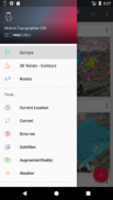
Mobile Topographer GIS


توضیحات Mobile Topographer GIS
انتخاب محبوب از حرفه ای ها،
تلفن همراه نقشه بردار است ... دیدار است ...
GIS .
شما هم اکنون می توانید بدون هیچ گونه محدودیت به پیچیدگی و یا حجم اطلاعات انجام یک بررسی کامل.
حال حاضر سعی کنید همراه نقشه بردار GIS با استفاده از سه روز دوره آزمایشی رایگان. فقط دانلود نرم افزار و با ادامه او روش اشتراک. اگر چه، شما خواسته خواهد شد که به ارائه اطلاعات صدور صورت حساب، شما نمی خواهد قبل از پایان سه روز از دوره آزمایشی رایگان شارژ شود. شما می توانید اشتراک خود را در هر زمان در طول دوره آزمایشی سه روز لغو، رایگان می باشد. اتهامات تنها رخ خواهد داد، اگر در پایان از سه روز شما همچنان به یک اشتراک فعال داشته باشند. را
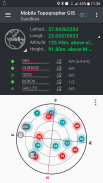
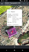
- جمع آوری خوانش GNSS با استفاده از افزایش دقت و صحت (GPS، GLONASS، گالیله، Beidou، صور فلکی QZSS کیفیت مختصات پشتیبانی).
- اتصال گیرنده GNSS خارجی خود را از طریق مکان های ساختگی و استفاده از تلفن همراه Topogrpaher GIS به عنوان یک واحد پردازش.
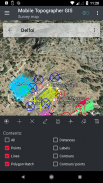
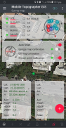
- نمایش داده ها را به CRS WGS84 و یا شما محلی پیش بینی شده.
- تبدیل از WGS84 به محلی CRS بینی و بالعکس.
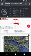
- طرح ریزی زمان واقعی بر روی نقشه.
- *** NEW *** عکس سفارشی یا سرور WMS به عنوان پس زمینه بر روی نقشه.
- یافتن یک نقطه مشخص شده در دنیای واقعی با استفاده از "رانندگی من"
- ارتفاع محاسبه Orthometric در پرواز با استفاده از مدل EGM یا شبکه های ارتفاع محلی که در آن در دسترس نیست.
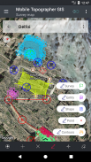
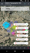
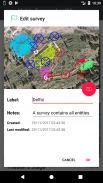
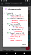
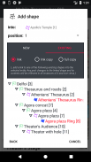
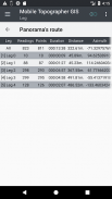
- سازماندهی کار خود را به امتیاز - اشکال - موجودیت ها و نظرسنجی ها. شما هم اکنون می توانید امتیاز خود، گروه های چند نقطه، لاینها چند، و چند ضلعی چند با سوراخ ایجاد کنید.
- ایجاد یک نقاشی کامل با جزئیات به همان اندازه که شما می خواهید.
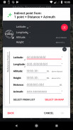
- *** NEW *** ابزار نقشه برداری. اضافه کردن نقاط غیر مستقیم از طریق در از گزینه های زیر: 1 نقطه + فاصله + آزیموت، 2 امتیاز + فاصله + انتخاب، 2 امتیاز + آزیموت، 3 امتیاز + فاصله، نقطه میانی خط، خط تقسیم، گسترش خط، خط موازی، عمود بر خط .
- آشیانه شغل خود را در هر سطح تودرتو، برای ایجاد یک فوق بررسی.
- اشتراک گذاری داده ها بین مشاغل با لینک فعال.
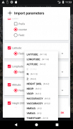
- شغل تبادل بین دستگاه تلفن همراه خود و کامپیوتر رومیزی خود را، با واردات - صادرات توابع با استفاده از تمام فرمت های رایج کلیپ برد چند منظوره، CSV، .KML، های .gpx، .dxf و شکل فایل های (قالبهای shp - .shx -. DBF)
- همکاری با شرکای خود را با تبادل و به اشتراک گذاری از یک نقطه برای تکمیل شغل.
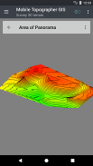
- ایجاد زمین 3D از یک منطقه به سادگی راه رفتن را از طریق آن.
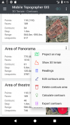
- محاسبه خطوط و اضافه کردن آنها را به بررسی خود را با سرعت رعد و برق.
- نمایش یک مدل 3D واقعی به طور مستقیم به دستگاه شما است.
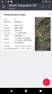
- ذخیره یک مسیر با داده های آن است.
- ماهواره نمایش GNSS با اطلاعات سیگنال در هر دو نمایش قطب نما و یا AR.
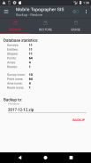
- پشتیبان گیری و بازیابی اطلاعات خود را با استفاده از یک فایل SQL. DB.
به دوران نقشه برداری تلفن همراه خوش آمدید ...!
اطلاعات بیشتر در مورد تلفن همراه نقشه بردار GIS در:
http://applicality.com/projects/mobile-topographer-gis/
دانلود راهنمای کاربر را از:
http://applicality.com/app_documentation/web/MobileTopographerGIS_Manual.pdf


Mobile Topographer GIS - اطلاعات APK
نسخه APK: 6.0.15حزمة: com.applicality.mobiletopographergisآخرین نسخه Mobile Topographer GIS
سایر نسخهها


اپلیکیشنها در دسته مشابه

شاید دوست داشته باشید...


